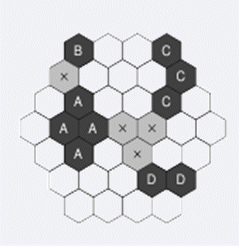
The input contains several scenarios. Each scenario begins with an integer number H , which specifies the size of the land, 2 H 20 . Then there are 2*H - 1 lines representing individual ``rows" of the land (always oriented as in the picture). The lines contain one non-space character for each parcel. It means the first line will contain H characters, the second line H + 1 , and so on. The longest line will be the middle one, with 2*H - 1 characters. Then the ``length" descends and the last line contains H parcels, again. The character representing a parcel will be either a dot (``.") for the land that is not owned by the investor, or one of the uppercase letters ``A", ``B", ``C", or ``D". The areas of parcels occupied by the same letter will always be connected. It means that between any two parcels in the same area, there exists a path leading only through that area. Beside the characters representing parcels, the lines may contain any number of spaces at any positions to improve ``human readability" of the input. There is always at least one space between two letters (or the dots). After the land description, there will be one empty line and then the next scenario begins. The last scenario is followed by a line containing zero.
 BZPRO
BZPRO